

ISLAMABAD : From the mighty stretches of the Karakoram in the North to the vast alluvial delta of the Indus River in the South, Pakistan remains a land of amazing adventure and nature. Trekking, mountaineering, white water rafting, wild boar hunting, desert jeep safaris, camel and yak safaris, trout fishing and bird watching, are a few activities, which entice the adventure and nature lovers to Pakistan.
Pakistan is endowed with a rich and varied flora and fauna. High Himalayas, Karakoram and the Hindukush ranges with their alpine meadows and permanent snow line, coniferous forests down the sub-mountain scrub, the vast Indus plain merging into the great desert, the coast line and wetlands, all offer a remarkably rich variety of vegetation and associated wildlife including a fauna, both endemic and migratory. Ten of 18 mammalian orders are represented in Pakistan with species ranging from the world’s smallest surviving mammals, the Mediterranean Pygmy Shrew, to the largest mammal ever known; the blue whale.
Islamabad
The capital city of Pakistan, Islamabad is located in the northwest of the country on Potohar Plateau. This area has been significant in history for being a part of the crossroads of the Rawalpindi and the North West Frontier Province. The city was built in 1960 to replace Karachi as the Pakistani capital, which it has been since 1963. Due to Islamabad’s proximity to Rawalpindi, they are considered sister cities.
Islamabad is a clean, spacious and quiet city with lots of greeneries. The site of the city has a history going back to the earliest human habitations in Asia. This area has seen the first settlement of Aryans from Central Asia, ancient caravans passing from Central Asia, and the massive armies of Tamerlane and Alexander.
To the north of the city you will find the Margalla Hills. Hot summers, monsoon rains and cold winters with sparse snowfall in the hills almost summarize the climate of this area. Islamabad also has a rich wildlife ranging from wild boars to leopards.
Gilgit Valley
Gilgit Valley makes the trade center of the region for centuries. It is the capital town and administrative center of province of Gilgit-Baltistan. The area is fed by waters of Hunza, Ghizer and Indus rivers along with the several of their tributaries. Gilgit has also been an important city on the historical Silk Route, facilitating religions to spread across trans boundaries. Shina is the language spoken in Gilgit while English and Urdu is widely spoken in the region. Of particular note, Naltar is a picturesque Greenland surrounded by high peaks with accessible glacial lakes, perfect resorts for winter skiing.
Furthermore, Kargah valley is only at 10km distance for Gilgit with Kargah Buddha a rock wall carved Buddha dating back to 8th century AD and ruins of a Buddhist monastery and Stupa. Other valleys include Danyore, Bagrot, Nomal and Oshikhandas.
Hunza Valley
Hunza Valley is a mountainous valley located in Gilgit. The main town of Hunza, Karimabad (formerly known as Baltit) is the capital as well as most popular tourist destination of Hunza. As famous as the valley is for its beauty, the people of Hunza are also well-known for their friendliness and hospitality. Hunza’s tourist season is generally from May to October, because in winter the Karakoram Highway is often blocked by the snow. Unlike most places in Pakistan, Hunza valley has a very high literacy rate of more than 90%.
Chitral Valley
Chitral Valley at an elevation of 1128 meters has Afghanistan on its North, South and West. It is surrounded by the Wakhan, Badkhshan, Asmar and Nooristan area of Afghanistan in the north, west and south-west. On its southern boundary lies Dir. In the east lies Gilgit agency and Swāt Kohistan. The narrow strip of Afghan territory, Wakhan, separates it from Tajikistan. The 7,788 meters (25,550 ft) Trichmir, the highest peak of the Hindukush mountain, dominates this 322km long exotic valley. No mountain in the region is less than 4000 feet and more than 40 peaks have an altitude of 20,000 ft. Chitral is divided into small valleys by the mighty Hindukush range. Chitral is undoubtedly the most romantic, captivating and enchanting place in the majestic Hindukush range. It is a mountainous area in the extreme north of Pakistan.
The landscape of Chitral is extremely mysterious, with its steep harsh mountains, lush green valleys, beautiful meadows and big glaciers, which have made it one of the most difficult and inaccessible area of the world. The weather in Chitral is extremely harsh and cold in winter while the summer is very pleasant. There are certain famous places and valleys in Chitral like Garam Chashma valley, Booni, Golen valley, Madaklasht valley, Arandu, Birir, Rumbur and Bumburat.
Karakoram Highway
At a height of 15,397 ft. above sea level, the Karakoram Highway (KKH) is the highest paved international road. It is also considered as the 8th wonder of the world. The highway connects Pakistan’s Gilgit-Baltistan region to China’s Xinjiang region which is why it has also been nicknamed the ‘Friendship Highway’ in China.
The construction of the highway began in 1959 and was completed in 1979. It was opened to the public in 1986. Many Chinese and Pakistani workers lost their lives to the construction of this monument of a highway that people come to view. The beauty of the nature that can be seen from the highway and how the mountains were cut to reach such a height is beyond belief.
Quetta
Sitting at 1,680 metres (5,500 feet) above sea level, Quetta, the capital of Balochistan province, occupies a strategic position since the boundaries of Iran and Afghanistan meet here, and the Bolan Pass lies on important lines of communications. Located in a river valley, it is connected by rail with Lahore, (727 miles), with Peshawar (986 miles), and Karachi (536 miles). A new road connects it with Karachi through Khuzdar, Makran and Las Bela. It is also connected with Zahidan (Iran) by rail.
Quetta derives its name from the Balochi “Kuwatta”, which means a fort. The city is surrounded by imposing hills like Chiltan, Takatoo, Murdar and Zarghun. It lies 1692 meters above sea level at the mouth of Bolan Pass. It is famous for its honey sweet apples and many other verities of fruit. Quetta abounds in various varieties of apples and grapes. The orchards clutter the entire suburbs of Quetta and other important towns. For the abundance of fruit, Quetta is rightly called as the Fruit Basket of Pakistan.
Peshawar
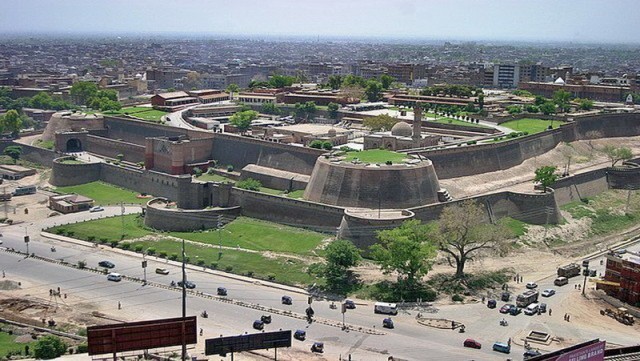
The capital of Khyber-Pukhtunkhwa (NWFP), is a frontier town, the meeting place of the subcontinent and Central Asia. It is perhaps the oldest living city in this part of Asia – a place where ancient traditions jostle with those of today, and where the bazaar in the old city has changed little in the last hundred years except to become the neighbour of a modern university, some modern hotels, some international banks and one of the best museums in Pakistan. No other city is quite like old Peshawar.
The bazaar within its walls is like an American Wild West movie costumed as a Bible epic. Pathan (Pukhtun or Pashtun) tribesmen stroll down the street, their hands hidden inside their shawls and their faces partly covered by the loose ends of their turbans. With his piercing eyes and finely chiselled nose, the Pathan must be the handsomest man on earth. Overlooking all the crowded and narrow streets are the massive Balahisar Fort, and the elegant Mahabat Khan Mosque. The railway, built by the British, divides Peshawar’s old town from the Cantonment, laid out by the British after 1850, with wide tree-lined streets bordered by once gracious administrative buildings and spacious bungalows in large gardens.
Abbottabad
Abbottabad is popular tourist attraction because of its scenic mountains and beautiful hill stations like Ayubia, Thandiani and Galyat. Abbottabad founded in 1853 and named after Major James Abbot, was headquarter of Hazara during British Raj. There are still few active churches in the city.
Abbottabad has been attracting tourists to the city since the colonial era, as it is a major transit point to all major tourist regions of Pakistan such as Nathiagali, Ayubia and Naran. The Karakoram Highway, which traces one of the paths of the ancient Silk Road, starts from Hasan Abdal on the N5 and heads north passing through the city, eventually reaching Khunjerab Pass. The Karakorum Highway is a major attraction itself for its views. The Karakoram, Himalayas and the Hindu Kush ranges can be approached from Abbottabad, and it continues to be a transit city for tourists, serving as a base for visiting nearby places, such as Hunza, Gilgit, Skardu and Indus Kohistan, of the karakoram range.
Swat Valley
The lush green and historic Swat Valley. In the Malakand Division lies between 34’40’ to 35′ N latitude and 72′ to 740-3 E longitude and is part of the Provincially Administrated Tribal Area (PATA) of the Khyber Pukhtunkhwa province of Pakistan. The valley is an integral part of the strategic and significant region where three parts of the Asian continent—South Asia. Central Asia and China meet. The names found in ancient sources for Swat are Udyana and Suvastu because of the scenic beauty of the valley and the name of the river respectively.
The magnificent Swat Valley popularly known as the Switzerland of Pakistan, is situated north of Peshawar. In ancient times it remained centre of then flourishing Buddhist civilization still having its remnants found at various places.
The archeological sites and monasteries dating back to Buddhist era add to its historical charm. Surrounded by majestic mountains, Swat Valley is full of roaring rivers, lush green forests and snow-covered peaks adding to its natural attraction. In the valley, green fruit, orchards, beautiful lakes, gushing streams and a fascinating landscape make it a place worth seeing.
Taxila
Taxila or Takshashila was an ancient city in what is now north-western Pakistan. It is an important archaeological site and in 1980, was declared a UNESCO World Heritage Site. Its ruins lie near modern Taxila, in Punjab, Pakistan, about 35 km (22 mi) northwest of Rawalpindi.
Taxila was situated at the pivotal junction of South Asia and Central Asia. Its origin as a city goes back to c. 1000 BCE. Some ruins at Taxila date to the time of the Achaemenid Empire in the 6th century BCE, followed successively by Mauryan, Indo-Greek, Indo-Scythian, and Kushan periods. Owing to its strategic location, Taxila has changed hands many times over the centuries, with many empires vying for its control. When the great ancient trade routes connecting these regions ceased to be important, the city sank into insignificance and was finally destroyed by the nomadic Hunas in the 5th century. The archaeologist Alexander Cunningham rediscovered the ruins of Taxila in the mid-19th century.
Khewra Salt Mines
The Khewra Salt Mine (or Mayo Salt Mine) is located in Khewra, north of Pind Dadan Khan, an administrative subdivision of Jhelum District, Punjab Region, Pakistan, which rises from the Indo-Gangetic Plain. It is Pakistan’s largest and oldest salt mine and the world’s second largest.
It is a major tourist attraction, drawing up to 250,000 visitors a year. Its history dates back to its discovery by Alexander’s troops in 320 BC, but it started trading in the Mughal era. The main tunnel at ground level was developed by Dr. H. Warth, a mining engineer, in 1872 during British rule. After independence, the Pakistan Mineral Development Corporation took over the mine, which still remains the largest source of salt in the country, producing more than 350,000 tons per annum of about 99% pure halite. Estimates of the reserves of salt in the mine vary from 82 million tons to 600 million tons.
Lahore
Lahore is the capital city of the Pakistani province of Punjab. It is the second-most populous city in Pakistan after Karachi. The city is located in the north-eastern end of Pakistan’s Punjab province, near the border with the Indian state of Punjab. Lahore is ranked as a beta-world city, and is one of Pakistan’s wealthiest cities. Lahore is the historic cultural centre of the Punjab region and is the largest Punjabi city in the world.
Lahore exerts a strong cultural influence over Pakistan. Lahore is a major centre for Pakistan’s publishing industry, and remains the foremost centre of Pakistan’s literary scene. The city is home to the annual Lahore Literary Festival, considered to be one of South Asia’s premier cultural events. The city is also a major centre of education in Pakistan, with some of Pakistan’s leading universities based in the city. Lahore is also home to Pakistan’s film industry, Lollywood, and is a major centre of Qawwali music. The city also hosts much of Pakistan’s tourist industry, with major attractions including the famed Walled City, numerous Sikh shrines, and the Badshahi and Wazir Khan mosques. Lahore is also home to the Lahore Fort and Shalimar Gardens, both of which are UNESCO World Heritage Sites.
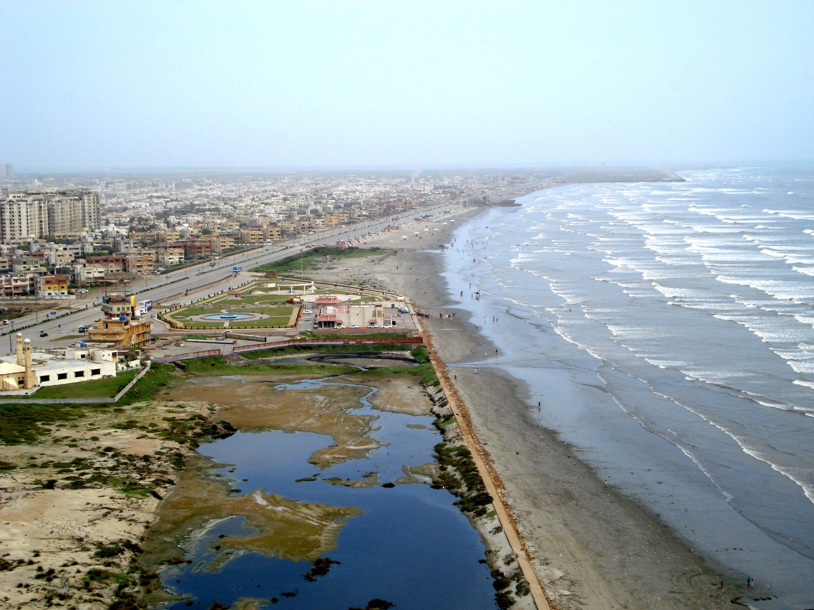
Karachi
Karachi, largest city and former capital of Pakistan, on the Arabian Sea near the Indus River delta. The capital of Sindh province, it is Pakistan’s chief seaport and industrial center, a transportation, commercial, and financial hub, and a military headquarters. It has a large automobile assembly plant, an oil refinery, a steel mill, shipbuilding, railroad yards, jute and textile factories, printing and publishing plants, media and entertainment industries, food processing plants, and chemical and engineering works. Karachi airport is one of the busiest in Asia. Karachi has a university and other educational institutions; the national museum, with a fine archaeological collection; and the tomb of Muhammad Ali Jinnah, founder of Pakistan.
Ranikot Fort
The Ranikot Fort also known as Dewar-e-Sindh (Great Wall of Sindh), with a circumference of about 26 km or 16 miles, is reputed to be the largest unexplored fort in the world. Since 1993, it has been on the list of tentative UNESCO World Heritage Sites. It is located in the Kirthar Range, about 30 km southwest of Sann, in Jamshoro District, Sindh, Pakistan. Ranikot is the most talismanic wonder of Sindh. Visible from five kilometers away its massive undulating walls twist and dip over the hills. Its walls, are built with dressed sandstone and reinforced with 45 bastions along the outer wall, of which 7 are rectangular and the remaining are round. All modified through the ages to accommodate the use of gunpowder, this perhaps makes it the largest fort in the world.